Monday, October 02, 2006

Dexter Deli and Sushi Bay

It appears that some change has come to the culinary organization on Dexter north of Mercer. The Dexter Deli, which was previously up by Starbucks, is now down in the new Neptune apartment building. Taking its place at Highland and Dexter is "Sushi Bay" - perhaps a welcome alternative when eating lunch out at work!

Thursday, September 28, 2006

Fall foliage tracker


This is pretty neat - weather.com has a fall foliage tracker. Looks like Washington is still in summer mode, despite these trees on my street being the first on the block to change colors. They are always the harbingers of fall for me!

Monday, September 18, 2006

Gothic Basin


Over Labor Day weekend, my friend lb and I went for a day hike out on the Mountain Loop highway. We decided to head up to Gothic Basin, since I'd recently heard from two different people how great it was up there. It was about 5.5 miles to get up to our destination, but well worth the climb. We were rewarded with striking rock formations, green valleys, tarns, and views of the surrounding peaks. When we first reached the basin we turned left instead of right and wandered down to the point where there was a sheer dropoff of about 1000 feet in elevation down to Weden Lake. Realizing this was not quite right, we backtracked and then made our way to Foggy Pond (frequently mistaken for Foggy Lake). We ended up taking the long way around, passing another pretty tarn with a waterfall on the way, but finally made it up to Foggy Lake. Though I have it on good authority that the lake often lives up to its name, it was in fact beautiful and clear when we were there. We picked our way around the lake so we could find a place to swim, though the swim itself consisted of a quick dunk and rushing back out to the warm rocks due to the frigid water temperature. Finally we turned our boots back downhill and made our way back. Foggy Pond tempted us with its much warmer water, but time was of the essence and we knew we needed to make haste in order to get back to the car before dark (it's not July anymore, Toto!). All in all it was a great hike, worthy of the praise it was given that inspired us to go in the first place.

As an added bonus, we stopped for dinner at the first little restaurant we saw, and were treated to the musical stylings of a Guns N' Roses cover band called Max Axle, complete with dancing groupies. Click here to see the rest of the pictures!

Wednesday, August 23, 2006

Robin Lakes

Many people I know use the Mountaineers' "100 Classic Hikes in Washington" as their hiking bible. It's for good reason: the hikes described in that book are practically guaranteed to be awesome. One of the ones that has stuck out in my mind for a while, but I hadn't had time to do, was #53, Tuck and Robin Lakes. This past weekend, I finally made it up there for an overnight trip with my labmate ks.

We got a bit of a late start - feeding cells in the morning combined with a longer-than-expected drive out beyond Cle Elum resulted in a 12:30 start time. This meant that we were climbing up the trail at the peak of the heat of the day - with packs on - but oh well. The first part of the trail is extremely flat, following the Cle Elum river up to Hyas Lake and Upper Hyas Lake. A little while after passing the lakes, we started heading uphill. The up-ness didn't take many breaks after that. We came to a junction and took a right, towards Tuck and Robin Lakes. I think that the trail up to Tuck was the hardest part - the trail wasn't graded very well, and the dusty steepness was pretty tricky. We stopped for lunch on a flat slab of granite - and also provided some lunch (in the form of our skin) to some local biting flies.
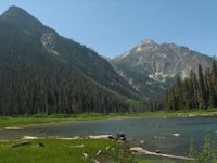
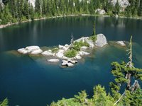
We eventually made it up to Tuck lake, which was quite beautiful. It had some amazing rock islands in the middle of it that I just yearned to swim out to - but alas, it was already after 5:00 and we still had another mile and 1000 feet in elevation to go to get to Robin Lakes.

The trail up to Robin Lakes bordered on a scramble at times. Much of it was marked with cairns as it passed over granite, which doesn't lend itself well to trail-cutting. We passed a group of people who tried to convince us that there were no more campsites left at Robin - but then they admitted that they were just joking. We went around a knob, then up some more granite, then up some more granite, and just when we thought we couldn't take anymore, we came over the crest of the basin and the Robin Lakes came into view. They are beautiful lakes, very different from Tuck and Hyas in that there are far fewer trees (and more granite) surrounding them. Just a tiny bit of snow remained on some of the north-facing slopes.

Since the sun was beginning to set, we knew we had to find a campsite in a hurry. However, since the sun was setting, the light was all pretty, so we kept taking pictures and delaying our progress. Somewhat fortuitously, ks wanted to gain higher ground and climbed up on a bluff, where a perfect campsite was hiding (the rest of the good campsites having been long occupied that day). In between photo ops, we managed to get the tent set up and water purified, and mac and cheese cooked. We ended up eating in the dark, but that was fine.

The stars were out and absolutely amazing - a late rising crescent moon meant we had completely dark skies. I saw at least a half-dozen shooting stars, including one that was particularly bright.

The next morning we got up early and took more pictures - for about 3 hours - before even eating breakfast. We met a fellow photographer who was there by himself - and agreed to swap photos once we returned home. While pumping water down by the lake we encountered some of the area's many resident mountain goats. They just sauntered down the trail, right past us, causing me to break out my camera in 2 seconds flat to take a ton of pictures. My favorite one is here:
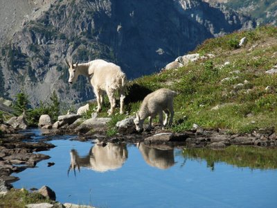

Finally, we managed to eat breakfast, break camp, pack up our packs, and hit the trail at about 11:30. The way down was no easier than the way up - especially with packs on. We stopped at Tuck lake for a snack break and a chance to splash my face in the water (alas, no time to swim) and then proceeded on down. By the time we got to the flat part, we were pretty ready to be done - but we still had 4 miles to go. Towards the end of the trail we passed a large group that also included 2 horses. Finally, after crossing the aptly-named Skeeter Creek, we reached the trailhead and our car.

The ice cream bars and cherry cokes we had at the little general store we stopped at were to die for.

The rest of my pictures can be found here.

Thursday, August 17, 2006

Chinook salmon in the Ballard locks fish ladder

The first time I ever came to Seattle, my hosts took me to the Ballard Locks to witness the amazing movement of boats between two different bodies of water at different heights. It's all done without the use of pumps; pretty cool! We also walked over to the fish ladder - the series of pools of water through which spawning salmon can swim upstream in order to reach their breeding grounds - the other option being to jump over the dam (!), or to happen to pass through the locks. At that time there were no fish in the ladder, nor have there been on the handful of other times I've stopped by the locks to enjoy the view. Finally, this summer, I decided to go when the fish were there - which apparently also means that that is when the people are there too! I guess it was my own fault for going on a beautiful sunny Sunday afternoon in August.

Well, I have to say it was really worth it to finally see the salmon there. I missed the really big run of sockeye earlier in the month, but there were still plenty of chinook to be impressive. Apparently the coho run towards the end of the month, so you still have time to go and see them if you get a chance!

Wednesday, August 16, 2006

One of these things is not like the others

 
This weekend nyanko headed out of town with a note on the whiteboard: "Please eat my blueberries!" I decided this was a perfect opportunity to try making some blueberry muffins. Round #1, from my Better Homes and Gardens cookbook (top right in picture above), turned out to be fairly plain and boring - but still edible. Having never made blueberry anything before, I was surprised at the way the blueberries popped and drizzled upon baking.

For round #2, I googled for blueberry muffin topping and came up with a Bed and Breakfast website that had a recipe with a streusel topping. Differences from the first recipe included the addition of lemon yogurt, baking soda, and a few more blueberries (plus the yummy topping) making this batch much more fluffy and flavorful. I have one more aliquot of blueberries left in the fridge.... maybe I'll try making some blueberry coffee cake next! Posted by Picasa

Monday, August 07, 2006

Summerland

 
Yesterday nyanko and I went for another hike - one that was slightly more normal this time. We headed down to the eastern side of Mt. Rainier to hike to Summerland, along the Wonderland trail. The trail rose gradually through the forest, then switchbacked up a bit to reach the meadow at Summerland. The wildflowers were definitely amazing and the views of the mountain were glorious. While hiking the trail beyond Summerland, we looked back and saw a momma bear and two cubs crossing the trail - glad we were far away! Later we also saw a marmot (not a monkey), that wouldn't whistle despite me getting coming within 10 feet of it before it scurried away. The hike back down was uneventful (no ball bearings this time!).

Since we were in the area, and nyanko hadn't been to Sunrise before, we continued up the road to take in the views from up there. The meadows were full of beautiful purple lupine. The garden outside the visitor center helped us identify most of the varieties of wildflower we had seen on our hike - very helpful! On the drive home, I glanced back and saw the nearly-full moon rising over the mountain - a great ending to the day. Posted by Picasa

Wednesday, July 26, 2006

Summer in Seattle

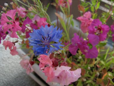
Well, summer is here and it's been hot, hot, hot. Unusually hot for our neck of the woods. Anyway, in the meantime, the flowers on my balcony have been putting on quite a nice show. Click here to see some pictures (Blogger is being stinky at the moment and won't let me upload the image)!

Update 1:04 pm 07/26/06:

Tuesday, July 25, 2006

Juxtaposition

I walked down to Fado for a pub night last night, and on my way, passed the construction site for a Four Seasons hotel. The location is great - right in the heart of downtown, with a perfect view of the water. And then I walked two steps more and ran into the Lusty Lady...


Friday, July 21, 2006

Mailbox Peak

When trying to pick out a hike for last weekend, my roommate (nyanko) and I had a few criteria. We needed to be done by early afternoon, and I wanted it to be at least a little challenging, since I'm kinda sorta training for a much bigger hike later in the summer (TBD). Somehow this led us to choose Mailbox Peak, for its proximity (satisfying criterion #1) and for its steepness (#2). I had read many reviews, I KNEW that it was steep (the trail gains 4000 feet in 2.5 miles), but somehow, knowing doesn't seem to placate your muscles when the slope is so steep that your heels are no longer touching the ground. Ultimately, we made it to the top, and it was well worth the work. The views were awesome (we could see Mt. Rainier, Mt. Adams, possibly Mt. St. Helens, Puget Sound, the Olympics, Seattle, Mt. Si, Mt. Baker, and Glacier Peak, just to name a few...). The wildflowers were some of the best I've ever seen. There were, in fact, two mailboxes and a newspaper holder on the peak, as promised, but the fire hydrant that I'd heard about was no longer there. Our much anticipated lunch was extraordinarily yummy, especially because nyanko brought along cherries. A number of people, using the trail as a training hike, got to the top, dumped out the water weights they were carrying, and headed back down after only a few minutes' rest. Crazy! The way down was about as slow going as the way up - just because it was so steep! I tried to take some pictures to convey the steepness, but unless you were behind the camera, I think it's still hard to tell. Of course, it was also slow going because I had to stop every few steps to take more pictures of the wildflowers :). Once we were back in the forest (having successfully skirted the giant talus slope that we almost climbed up on the first part of the trip till someone came by and hollered that there was a way around), we reentered the forest and started following the green dots (trailmarkers, in this case). We had actually taken a lesser trail for part of the way up the hill, which had been marked with a set of older green dots - since it's not a maintained trail, it was easy to lose track of where the main trail was actually going. Anyway, we took the correct (or at least, more used) path back down the hill, though it wasn't too much better. Things got tricky when we got to the part where the trail was not only steep, but also covered in gravel, which acted like marbles or ball bearings, and wreaked havoc on our exhausted senses of balance. I actually fell several times, but with no major injuries. By the time we got back down to the flat forest road that lead back to the trailhead, we were overjoyed. Despite all the foibles and glitches, we had a great time and I'm glad we did it. But next time, we're definitely going to find a more "normal" trail. Click here for some more photos!